Consolan - What Is It?
|
|
I suppose if you are in thick fog while on a boat or, more critically, in an airplane (in the air, of course), then all forms of navigational aids provide aid and comfort to a pilot. By 1961 when this article about the Consolan system was published in Radio-Electronics magazine, the most common navigational aids were radio direction finding (DF), radio direction and ranging (radar), long range navigation (Loran), VHF omnidirectional range (VOR), and dead reckoning [dead reckoning ;-)]. During World War II, the Germans developed another kind of radio directional broadcast system called "Sonne," their word for "sun," because of the radial antenna pattern it generated (see plots). English engineers created a version they called "Consol" ("by the sun"), and then the U.S. implemented a simpler version dubbed "Consolan" (i.e., Consol army/navy). All three systems required the navigator to listen for and count the number of dots and dashes during each broadcast interval, and then look up the corresponding position on a radial from the transmitter location. Here is the COLSOL and CONSOLAN excerpt from Radio Navigation Systems for Aviation and Maritime Use. Consolan - What Is It?
New navigation aid for small boats needs only a surplus long-wave receiver. and some simple modifications you can make. By Elbert Robberson I am accustomed to odd questions. Like, someone will telephone and say, "I am sailing single-handed to England next month. What kind of communications equipment can I get that doesn't cost much, and doesn't need any batteries to speak of, and that will bring help if I am dismasted in mid-Atlantic." The answer: homing pigeons. I can handle most questions of this type with similar answers. But last spring I began to get calls: "Tell me something about Consol. Is it good? What kind of equipment do I need to pick it up? How does it work? How accurate is it?" It seems that hundreds of yachting laddies were planning to enter the 1960 sailing race from Newport, R. I., to Bermuda. Word had passed down the grapevine about a new radio aid to navigation that would tell a skipper his position without having to shoot the sun with a sextant, or make pips behave on an oscilloscope, or twist a DF loop. This would make small-boat navigation as easy as falling off a bar stool. The idea had the boys drooling for the dope. All I knew was that there were Consol beacons broadcasting in Europe and that airplanes using them got around in the fog just fine. But the fact there are Consolan stations in the US that can be used by boats was apparently one of the best kept secrets in electronics.
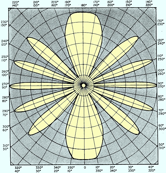
Fig. 1 - Fundamental pattern from which Consolan pattern is derived.
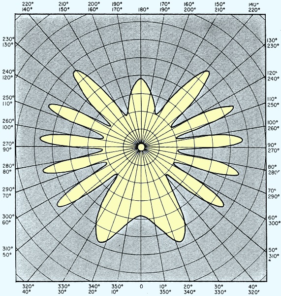
Fig. 2 - Effect of 90° lead on north and 90° lag on south tower.
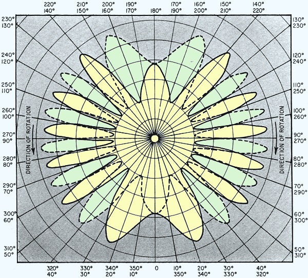
Fig. 3 - Consolan patterns produced by dephasing antenna elements alternately.
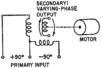
Fig. 4 - Goniometer makes pattern rotate.
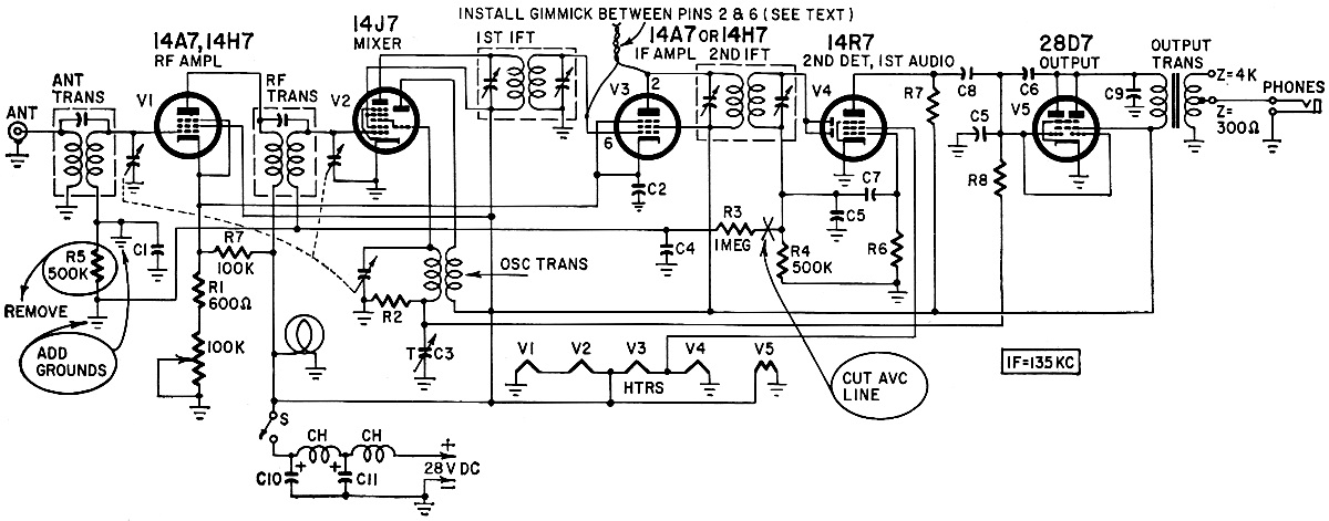
Fig. 5 - Modification of a surplus (Setchell-Carlson-524) receiver to receive Consolan.
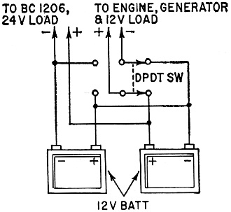
Fig. 6 - Battery hookup on author's boat.
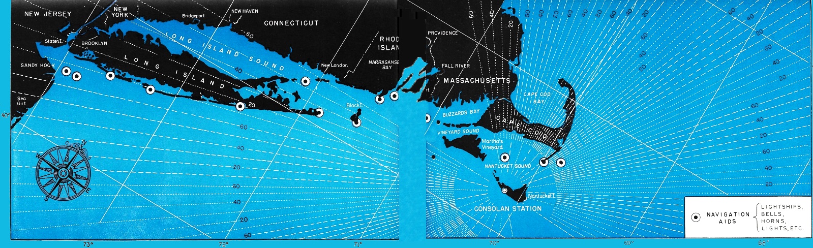
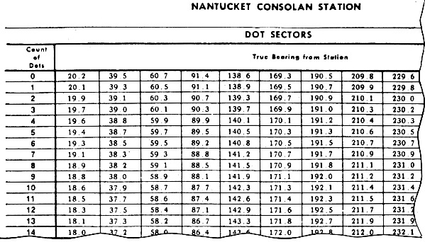
Fig. 7 - Portion of table showing bearings from TUK against given dot counts. It is likely that electronic service agencies around coastal waters will begin to hear questions about Consol and Consolan with increasing frequency. You can be the first in your neighborhood to know the answers. And there might be something in it for the shop able to set up radio receivers to pick up Consolan signals. Here is the information I have been able to dig up. During World War II, English pilots picked up curious radio signals from Germany. It was not long before they deduced that the directional pattern was just as useful for navigating Spitfires as Messerschmidts. This was Sonne, presumably so-named by the Germans because of the resemblance of the pattern to sunrays. When the British built their own stations, they named the system Consol. In the United States, a slightly different system is called Consolan. All of them produce the same end result: a long-range pattern of radial sectors of dots and dashes. Simply by tuning in the signal and counting the dots and dashes heard, a vessel's line of position may be obtained from a set of tables or a Consolan chart. The only special requirements for the receiver are that it tune to frequencies between 190 and 200 kc, and that it have a bfo. No tricky circuits or adjustments are needed. All you need are ears and the ability to count dots and dashes. Consolan stations are operating at Nantucket and San Francisco, and a Consol type station in Miami is scheduled for completion in late 1960 or early 1961. There are five Consol stations in Europe, and Japan has a similar system. How Consol works Three vertical radiators in a line spaced three wavelengths apart and excited in phase with a power ratio of 1 to 6.75 to 1 produce the radiation pattern shown in Fig. 1. If the phase of the north tower is advanced 90° and the south tower retarded 90°, the pattern will be squeezed as shown in Fig. 2. And if this is reversed, so the north tower lags by 90° and the south tower leads the same amount, the pattern is squeezed in the other direction, making a mirror image. If we attach a keyer to the phase-shifting networks so the end towers are alternately leading and lagging, the pattern flip-flops between the solid and dotted lines of Fig. 3. With the keyer making interlocking dots and dashes for the two end towers, a receiver moved around the station would pick up dots in one sector and dashes in the next "around the clock." Between sectors the dots and dashes would merge into an "equisignal." There would be 24 equisignals, and each could be used like a radio range to "home" on the station. To make the system useful on more than just 24 course lines, one more element is added: a rotating goniometer. The principle of the goniometer is illustrated in Fig. 4. This goniometer couples the transmitter to the towers so that, as it rotates, the excitation to the end towers undergoes a gradual change of phase from plus 90° to minus 90° (or the opposite). The effect is that the dot-and-dash lobes and the equisignal bearing lines rotate around the station. The goniometer is driven at a constant speed of 48 revolutions per hour, taking 75 seconds to complete a revolution. Attached slip rings control the dot-dash keyers and the station-identification keyers. At the beginning of a sequence, the end towers are disconnected and the identification keyer sends out the station's identification letters for 7.5 seconds on the center (nondirectional) tower. Then for 30 seconds, as the phasing changes through 180°, the end towers are fed interlocking dots and dashes. A 7.5-second silent period for an identification follows; then another 30-second phasing sweep. Each sweep 60 dots and dashes are sent out. The number and order of the dots and dashes you hear depends upon your geographical location with respect to the antenna lobes. Since equisignals are repeated approximately every 20° around the station, it is necessary for you first to know approximately where you are, but this ambiguity is of small importance in a boat because your position by reckoning (or guessing) will indicate in which of the sectors of the Consol pattern you are. In effect, your count of dots, or dashes tells you how far around the circle from the starting point the goniometer has turned to bring the equisignal to you. Hence, it gives your angular relation to the transmitting station. Thus, if you happen to be on one of the lines marked "60" on the chart, you are along the leading edge of a segment and will hear 60 dashes (or dots) before the segment passes you (minus a few as you get into the equisignal). If you are in the middle of a segment, however, it will sweep around to the equisignal halfway through the listening period, and you will hear about as many dashes as dots. Consolan is the same as Consol except that only two towers spaced three wavelengths apart are used. Due to the fact that three wavelengths very nearly amount to 3 miles at 190 kc, this saves a lot of ground area for the farmers. The lobe nulls become zero with Consolan, whereas they are filled in by the center tower of a Consol station. As far as the use of the facilities are concerned, however, operation is the same. Theoretically, to obtain a Consol (or Consolan) line of position, you tune the receiver to the frequency with the bfo on and the avc off. Immediately after the identification signal is sent in code, start counting the first thing heard, dots or dashes, until they blend into the equisignal. Then, just look on the Consol chart and find the line that corresponds to your count. For example, a Consolan line from Nantucket (TUK) for 40 dots brings you to the Kitchen Shoals buoy off the eastern tip of Bermuda. Consol chart lines are inscribed every 10 or 20 characters; to find intermediate lines, just interpolate. There are also Consol and Consolan tables for the various stations. These give bearing lines in degrees which can be marked on a conventional navigating chart. In practice, the equisignal may be several characters wide or obscured by noise, so that one or more characters will be lost in the mud. To get an accurate number in spite of this, we add one refinement to our counting. It is based on the assumption that, during the equisignal period, the same number of dots and dashes is lost. Because 60 dots and dashes are transmitted, we can tell the exact number of characters that were not recognized, by subtracting the total number of dots and dashes heard from 60. Divide this difference by 2, and you have the number of dots and dashes lost. For example, on Long Island Sound in my own boat, the Short Wave, I tune in TUK at Nantucket and start counting after the station identification is sent. I get 39 dots, then equisignal, then the dashes become audible and I count 17 dashes. Because 39 and 17 add up to 56, I see that I have lost four characters to make up the 60. This means that I lost two dots and two dashes. Adding the lost two dots to my count of 39 gives 41. Therefore, according to my chart, I am on the 41-dot line which extends from Mamaroneck, N. Y., eastward down Long Island Sound. At the present time, due to the lack of additional stations from which to obtain cross bearings, it is necessary to use a course line or to take a radio direction-finder bearing on one of the numerous radio stations along coastal waters to determine a "fix." However, in the many cases for which Consolan is appropriate, this is no great disadvantage. A simple regenerative receiver, vacuum tube or transistor, is entirely suitable for Consolan reception. Too many of these have been described in the literature for me to make any further suggestions on their construction. Another very good receiver for the purpose can be obtained from military surplus for under $10 - the Setchell-Carlson BC-1206 Radio Range receiver. This set is originally wired with avc and has no bfo. I altered one of these for the Short Wave by grounding the avc bus and by soldering a 114-inch length of insulated wire to the grid terminal of the if amplifier tube. Dressing this wire across the socket and around the plate terminal for the same tube introduces enough positive feedback, or regeneration, to cause the stage to oscillate when the sensitivity control is advanced. This self-oscillation serves the same purpose as a bfo, permitting reception of the CW Consolan signals. Fig. 5 indicates the changes made. The BC-1206 operates on from 24 to 28 volts. On the Short Wave, this voltage is obtained by connecting my two 12-volt engine batteries (the one in use and the reserve battery) in series, as shown in Fig. 6. This hookup, with a double-pole double-throw 80-ampere battery switch, permits using either of the 12-volt batteries on the engine and to operate auxiliary devices while making 24 volts available at all times for the Consolan receiver. One caution - using this hookup, it is imperative that the 24-volt receiver not be grounded. Otherwise, you will have serious trouble from an opposite engine ground when the switch is closed. The frequency range of the BC-1206 is 200 to 400 kc. The oscillator padder on the main tuning capacitor can be readjusted to extend the tuning range to 190 kc at the expense of losing a few unimportant kc on the high-frequency end of the band. The same effect could be obtained by realigning the if transformer tuning to bring in 190 kc when the tuning capacitor is fully meshed. The same kind of alterations can be made to conventional small-boat radio direction finders or low-frequency receivers not already equipped with a bfo. Another possibility is to construct a small self-contained heterodyne oscillator covering the range of from 190 to 200 kc. This should be built in a non-conductive container to give the circuit the maximum coupling to the input circuit of the receiver. To make a 194-kc CW signal audible, the external heterodyne oscillator is placed alongside the receiver and tuned to from 500 to 1,000 cycles above or below 194 kc. A compact transistorized oscillator designed for this purpose is available from R. B. Stoops, 52 Hoyt St., Stamford, Conn. The Consolan system is an interim aeronautical aid to navigation which will be used until some future date (my guess is that this is a long way off) when an "ultimate" aeronautical aid is decided upon. The construction and operation of US stations is taken care of by the Federal Aviation Agency. Tables listing the location and bearing angles of US Consolan stations are printed in the US Navy Hydrographic Office and Coast Guard Notices to Mariners available to mariners at no cost. The US Navy Hydrographic Office, Washington, D. C., also issues a chart on which Consolan lines for TUK (Nantucket, Mass.) are inscribed: Plotting Chart (Newport to Bermuda), H.O. 16,510-A ($1). The following aircraft charts containing Consol and Consolan angles may be purchased from the Coast and Geodetic Survey, Washington, D. C.: Aircraft Position Chart, North Atlantic, 3071 (10¢) Continental Entry Chart, East Coast, CEC-1 (50¢) Caribbean Sea, GLC-9 (50¢) Aircraft Positioning Chart, US-Honolulu, 3096 (for San Francisco, SFI) Aircraft Positioning Chart, Caribbean Sea 3073 (for Miami, MIA) Nothing is perfect, and Consolan is right up in there on this score, but here is a navigational aid for coastal waters that can be used to the fullest extent, requiring nothing more complicated than an ordinary "blooper" receiver. It is sure to find increasing use among boatmen as well as aviators. To be up to date, master its workings.
Posted May 4, 2023 |
|