On the Very Highs |
|
"Our first complete column devoted to the subject [of v.h.f. and u.h.f. signal variation], presenting material similar to that which follows, was withheld from publication at that time in compliance with censorship." That is an amazing statement from a time when almost any form of technical information that was not already public knowledge was withheld for the sake of the war effort. Nothing that might even remotely give the enemy an edge, and consequently possibly harm our troops, got past the government censors at the War Department. Most citizens and even media editors willingly complied. Compare that with today's 5th column traitors at most of the media outlets that not only can't wait to publish information that will aid and abet our country's enemies, but have been known to manufacture stories in order to make the U.S. look bad. On the Very Highs Conducted by E. P. Tilton, W1HDQ
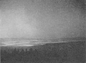
Early morning radiation fog, as it appears here filling the valleys in Vermont's Green Mountains, indicates a mild temperature inversion of the local type, with fair weather and. moderate v.h.f. bending in prospect.
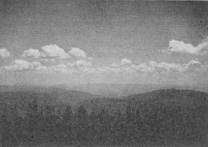
The familiar fair weather cumulus, appearing at mid-day or in the early afternoon as the result of warm air rising at a moderate rate, will dissipate in late afternoon, Prediction: fair weather and moderate v.h.f. bending.
The rapidly billowing wind-blown cumulus pictured here indicates turbulent conditions aloft. Thunderstorms may follow in warm weather, accompanied by high noise levels and generally poor radio conditions. V.h.f. hams should watch for DX openings in early summer, however.
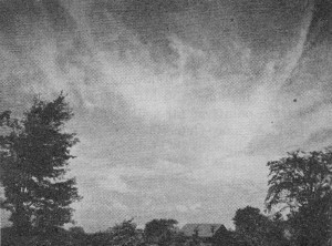
Cirrus "mare's tails," tell-tale vanguard of an advancing cold front, presage a change from fair to stormy weather and may possibly portend strong v.h.f. bending.
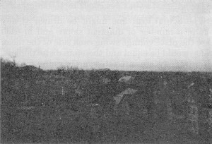
Nature's best but least-known visual warning of the presence of a temperature inversion resulting from an overrunning tropical air mass is the clearly defined smoke or dust layer marking the base of the warm moist mass. Look for it before sunrise or at dusk in clear calm weather; at any season. When you see it, rain is 36 to 48 hours away in summer; rain or snow 12 to 24 hour away in winter. Excellent radio conditions with strong v.h.f. signals may he expected at any time of the year.
A thickening altostratus haze veiling the sun, as shown above, is the result of warm, moist air aloft. This is the stage following that pictured at the bottom of this page, occurring immediately preceding precipitation. Shortly after the outbreak of war we proposed, in these pages, a study of aerology as a substitute for amateur operating activity. The response we received indicated a considerable interest in the subject, but this was at the time when the submarine menace along our coasts was at its height and, as a result, we were scarcely permitted even to print the word "weather," much less to go into a discussion of the means by which weather may be foretold by observation of v.h.f. and u.h.f. signal variation. Our first complete column devoted to the subject, presenting material similar to that which follows, was withheld from publication at that time in compliance with censorship. Now, with wartime radio developments accentuating the role that the v.h.f. and u.h.f. portions of the spectrum are destined to play in the future of all forms of radio activity, it behooves us to learn as much as we can about the effects of weather on propagation at these frequencies. So, if the experienced weathermen in the audience will find something else to do for a few minutes, we shall attempt a sketchy review of some of the points where observing amateurs in both aerology and radio meet on common ground. Like all sciences, aerology can become very involved in mathematics if one goes into it deeply enough; but, unlike most scientific pursuits, it also affords many opportunities for interesting work for anyone who is equipped with nothing more pretentious than a barometer, a thermometer and a pair of good eyes. If the person so equipped happens to be a ham who is casting about for something to do to while away a spare hour now and then, he will do well to get hold of a receiver which is capable of tuning the frequencies above 30 Mc. With nothing to be heard on Five, and with the probable reception on 112 Mc. limited to the WERS test periods, the f.m. broadcast band now offers undoubtedly the best opportunity for observation of variations in v.h.f, conditions. By the end of 1941 most of us had already become used to regarding strong v.h.f. signals from beyond visual distances as an advance warning of a storm on the way, but many were content to let the matter rest there. Perhaps there would have been more interest in daily operation on 56 and 112 Mc. in the dear, dead days prior to December 7th if more of us had taken the correlation between radio and weather a little further. Temperature Inversions As most extensions of the normal operating range of v.h.f. stations result from a temperature inversion of one sort or another, we should first understand what this term means in order to recognize the visible and audible effects associated with it. We all know that air temperature normally drops with an increase in altitude. The year-round average rate of decrease for the world's atmosphere is about 3° F. for each 1000 feet of altitude. Whenever the rate of decrease (commonly called lapse rate) is less than this figure an inversion may be said to exist, even though the air aloft may not actually be warmer than that at ground level. Under certain conditions, to be outlined later, the temperature up to several thousand feet may be several degrees higher than the ground reading. Bending of v.h.f. waves arises from the fact that the top of the radiated wave hits the warmer and rarer medium first, and thus is accelerated. As the warm air seldom is at any great height the bending usually serves merely to keep the wave traveling more or less parallel to the earth's surface, although in rare instances something approximating a skip zone is noticed. A pronounced inversion at low altitude, a common occurrence in warm weather, may increase the strength of a signal coming from the other side of town; while the maximum distance at which atmospheric bending, uncomplicated by other factors, has resulted in two-way work on 56 Mc. is somewhere between 350 and 400 miles. It is at distances between 75 and 200 miles that the effect of temperature inversions seems to be most pronounced, and the degree of variation in signal strength from night to night is greater with increasing frequency. Temperature inversions may be said to fall into two general classifications: those resulting from air-mass movement which may be continental in character, and the more limited type resulting from localized atmospheric convection. This is not the place to go into an involved discussion of air-mass analysis1 other than to say that a temperature inversion results when a mass of warm moist air (such as those originating in the Gulf of Mexico or out over the Pacific) overruns a mass of cool dry air of polar origin. This type of inversion can develop almost anywhere in the United States, at almost any time of the year. As warm moist air is of low density, it overruns the heavier cold air whenever the two types come in contact. The sloping "discontinuity" thus produced means interesting times for the v.h.f. enthusiast. Continental Air-Mass Inversions A typical weather cycle may consist of a period of cool clear weather, with high barometer and good visibility for two or three days: followed by gradually increasing cloudiness and warmer weather until the advent of a storm. Toward the end of the fair stage the strength of v.h.f, signal from points beyond the visual horizon will show a gradual improvement, increasing until about the time that the storm breaks, wiping out the inversion condition. Almost everyone knows from what direction storms come in his own locality. By watching the clouds2 and listening for variations in strength of stations in that general direction, the approach of a change in the weather may often be foretold as much as several days in advance. If one is fortunately situated as to altitude of the receiving location this correlation is particularly striking. An example is the prewar location of W1HDQ, which was several hundred feet above the surrounding country with a clear path of 50 miles or more toward the southwest. Here the signal-weather relationship showed up beautifully on 56 and 112 Mc. and, to a certain extent, on 28 Mc. also. During the evening following a clear day in spring, for instance, 56-Mc. signals might be heard from points as far southwest as Washington, D. C. - more than 300 miles away. Stations all along the line up to Philadelphia, about 200 miles in the same direction, would also be very strong, but signals from the New York area,125 miles away, would be only slightly above normal. This would place the maximum inversion area below New York. By the following evening we would have lost the stations below Philadelphia as rain moved up from the southwest, wiping out the inversion as it came toward us. By this time the amateurs in Springfield and Hartford would be working into the New York metropolitan area, with ordinary low-elevation locations at both ends of the 100-150-mile path. Around this time we would be noticing an increase in the strength of signals from the Boston area and up into New Hampshire, some 90 miles to the northeast. If our period of observation was continuous we would note a sudden drop in the strength of the New York signals, coinciding almost exactly with the arrival of rain in that area. Just preceding this some of the New York stations would have been working up into the Boston area. Cloudiness would have become general over Western New England by this time, and Boston-area signals would be very strong, even though 1200-foot elevations intervene along the path. Until the storm broke signals from the east and northeast would remain strong, though it would have become impossible to hear any but the very strongest stations to the southwest. Thus far we have been dealing only with the continental air-mass type of inversion, the idealized case described above occurring most frequently during the late spring or early fall. In winter we find the air-mass inversion in a practically pure state, although the extremes of bending are not so great as in warmer weather. In mid-summer the picture can be complicated) by so many factors that it took us several months of operation from our Wilbraham Mountain location before we could resolve any very reliable system for predicting weather by radio conditions, or vice versa. With certain variations, which each observer will have to learn for his own locality, the appearance of the clouds and the movements of the barometer furnish quite reliable warnings of the approach of good v.h.f. weather. With the exception of midsummer a rising barometer means increasing signal strength, while a falling or low barometer indicates lower signal levels. The appearance of cirrus clouds, those beautiful wispy "mare's tails" high in an otherwise clear blue sky, often gives advance warning of the approach of a storm by as much as 36 hours. The old saying about "mackerel scales and mare's tails" is useful for v.h.f. enthusiasts as well as for mariners. A hazy ring around the moon, evidence of warm, moist air aloft, has been recognized as a good sign by five-meter men since the earliest days of work on that band; and the periods around both full moon and new moon invariably are times of improved signal strength. "New moon, full moon, and over thirty on the barometer" is a good rule-of-thumb basis for predicting good times on the very-highs. Localized Convection Inversions We come now to the more localized convection type of inversion, a product of hot weather, which gives the boys fortunate enough to be located along our sea coasts, or near the Great Lakes or other large bodies of water or even adjacent to heavily forested areas, some of their most exciting moments. We all know that heated air rises; when it does, other air must come from somewhere to take its place. Cool air is heavier (at higher pressure) and therefore will tend to flow in to replace air which has risen as the result of heating by direct radiation from the sun or re-radiation from the earth. Thus, when we have a clear hot day along the sea-coast, by noon there is a fresh cooling breeze coming in from over the ocean, the air inland having been heated sufficiently to cause it to rise. The heated air, in turn, flows out over the ocean at high levels, creating an inversion condition which holds until well into the evening of practically every fair summer day. V.h.f. men who operate from points remote from the ocean know that mid-afternoon is the time during which the lowest signal strength of the whole day occurs, but the enthusiast located on Cape Cod, Long Island or the California Coast will find things interesting practically all day long in summer time. For the man located farther inland, the two hours around sunset will show strong signal peaks any sunny day in warm weather. As the earth cools more rapidly than the air above it, an inversion develops close to the ground shortly after sunset in almost any locality. The chilly spots frequently encountered when riding through open country at dusk after a hot day constitute a familiar example. The effects of the seacoast inversion described above may show up at points as much as 100 miles or more inland as the evening wears on; and when this sort of thing is combined with an inversion resulting from the approach of a tropical air mass, v.h.f. enthusiasts experience an evening which goes down in the history of "big nights." The coastal inversion is a phenomenon well known to occupants of the 112-Mc. band along the California coast. The tremendous updraft of warm air from the superheated desert country far inland moving out over the relatively cold Pacific produces a degree of bending of 112-Mc. signals seldom equaled elsewhere in the United States. So pronounced is the bending that flea-powered pack sets operating in the hills near Los Angeles frequently worked into San Diego, more than 100 miles away, and two-way work between home stations in San Diego and Los Angeles, using nothing more than simple receiving-tube rigs and half-wave antennas, was a common occurrence during the peak of the inversion season. The coast of Northern New England is blessed with very cold water, as Maine vacationists will testify. Although the country inland is not heated to the extent that prevails in California, the "inversion by subsidence" is a daily affair in mid-summer. A rare combination of subsidence and air-mass inversions prevailed on that now-famous date of August 21, 1941, when W2MPY made the long climb to the summit of Mt. Katahdin in the heart of Maine, arriving on the scene at the peak of the bending. The result is now history: a dozen or more contacts beyond the former 255-mile record for 112-Mc. work, and a 335-mile QSO with WIJFF at Newport, R. L - a record which will take some breaking when we get back to such things again. In describing his Katahdin experiences, W2MPY reported that on this trip, and on many others when he has worked long distances from high elevations, he was actually able to "see the inversion," a phenomenon also observed by your conductor in his mountain-climbing days. It took an aerology textbook3 to give us the answer to this one. In practice, its appearance has turned out to be one of the most reliable visual warnings of the existence of both subsidence and air-mass inversions. Smoke and Dust Layers During hot weather, particularly after a dry spell, the rising heated air carries aloft a considerable amount of dust. When this dust strikes an overrunning layer of moist tropical air it can rise no further, with the result that it spreads out at the bottom of the warm layer, clearly marking the height at which v.h.f. signals are bent. In industrial areas smoke in the air serves the same purpose, with the added advantage that the smoke generally rises whether there is any appreciable warming of the earth's surface or not. We have observed the occurrence of this brownish-gray smoke/dust layer on many occasions, both in winter and in summer, and it has never yet failed as a warning of a storm on the way. Its appearance may give 36 hours or more warning of a change in the weather (from fair to stormy) in the summer, when air-mass movement is slower, and 12 to 24 hours in winter. It should be an equally good harbinger of periods of strong v.h.f. signals. The foregoing is just a meager glimpse of the vistas which will be open to the v.h.f.-minded amateur after the war, but it will serve to show that operation on the very-highs can be a whole lot more than a nightly round of friendly chats with the gang in our own locality, important though these contacts loom in our picture of amateur radio as a source of relaxation and enjoyment. The events of December 7, 1941, interrupted ten years of continuous operation on the v.h.f. bands on our part, but we've found this weather business a splendid antidote for that empty feeling we used to get when we looked across the Connecticut River Valley to that tower of ours high up on Wilbraham Mountain. Cloud Stalking Most of the time during our six-month sojourn in Key West, now concluded, we kept an eye peeled for interesting cloud formations, trying all the while to imagine what operation on 56 and 112 Mc. would have been like down there. There, as elsewhere in open flat country, the general trends were much easier to discern than in rugged country like our native New England; and therein lies the beauty of cloud chasing as a hobby. If one takes the trouble to learn a little about aerology (and he need not get to the calculus-and-slide-rule stage) he will still have to figure out conditions for his own locality' himself when it comes to tying weather and radio "signs" together. Since Pearl Harbor we've been finding an ever-increasing interest in books dealing with the weather, and we've been stalking clouds with a camera whenever we could get the necessary film. We find this a most enlightening pursuit, especially when carried on in conjunction with a daily log of radio and weather observations, even though the latter may include nothing more than an occasional glance at the barometer and a check on the gyrations of the weather cock on the steeple of the town hall. Operation on the very-highs is going to be a source of even greater pleasure and satisfaction, as a result of this enforced interlude, when the current unpleasantness is over. ******* Before this material appears in print we shall have returned to Boston, where we will remain for a short period, following which we expect to be off on another assignment afield, this time outside the continental limits of the United States.We shall continue to submit copy whenever time and conditions permit, and we will especially appreciate hearing from any of the amateur fraternity who care to write. For the time being, the mailing address had better be: % ARRL, 38 LaSalle Road, West Hartford 7, Conn. 1 "Weather And the Ocean of Air," by Major W. H. Wenstrom (Houghton-Mifflin Co.), provides the most readable discussion of air-mass theory we have yet found. More strictly technical, but still understandable, is the paper, "An Introduction to the Study of Air Mass Analysis," by Jerome Namias and others, contained in the Bulletin of the American Meteorological Society, Vol. 17, Nos. 6 and 7. 2 The accompanying photographs show the appearance of typical formations. Scenes (1) and (2) were taken from the summit of Glastenbury Mountain, near Bennington, Vermont; the others at various points around Springfield, Massachusetts.
Posted April 22, 2020 |
|